Neptune and Triton Moon

Neptune and Triton Moon

Neptune and Triton Moon

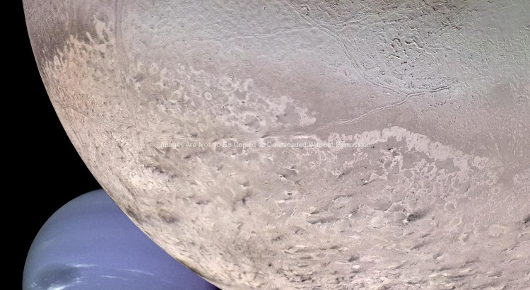
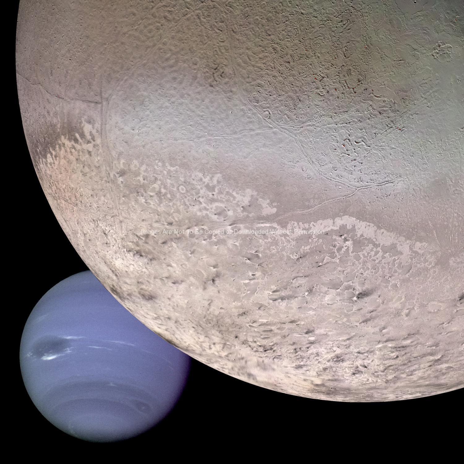
NASA Stock Photos – This computer generated montage shows Neptune as it would appear from a spacecraft approaching Triton, Neptune’s largest moon at 2706 km (1683 mi) in diameter. The wind and sublimation eroded south polar cap of Triton is shown at the bottom of the Triton image, a cryovolcanic terrain at the upper right, and the enigmatic “cantaloupe terrain” at the upper left. Triton’s surface is mostly covered by nitrogen frost mixed with traces of condensed methane, carbon dioxide, and carbon monoxide. The tenuous atmosphere of Triton, though only about one hundredth of one percent of Earth’s atmospheric density at the surface, is thick enough to produce wind-deposited streaks of dark and bright materials of unknown composition in the south polar cap region. The southern polar cap was sublimating at the time of the Voyager 2 flyby, as indicated by the irregular and eroded appearance of the edge of the cap.

Keywords: NASA, Neptune, Space photos, Triton, Moon

Earth and Moon from Galileo Spacecraft GPN-2000-001437

Earth and Moon from Galileo Spacecraft

Earth and Moon from Galileo Spacecraft

NASA Stock Photos – During its flight, the Galileo spacecraft returned images of the Earth and Moon. Separate images of the Earth and Moon were combined to generate this view. The Galileo spacecraft took the images in 1992 on its way to explore the Jupiter system in 1995-97. The image shows a partial view of the Earth centered on the Pacific Ocean about latitude 20 degrees south. The west coast of South America can be observed as well as the Caribbean; swirling white cloud patterns indicate storms in the southeast Pacific. The distinct bright ray crater at the bottom of the Moon is the Tycho impact basin. The lunar dark areas are lava rock filled impact basins. This picture contains same scale and relative color/albedo images of the Earth and Moon. False colors via use of the 1-micron filter as red, 727-nm filter as green, and violet filter as blue. The Galileo project is managed for NASA’s Office of Space Science by the Jet Propulsion Laboratory.

Keywords: Earth, moon, Galileo spacecraft, NASA

The Moon's North Pole GPN-2000-000473

The Moon’s North Pole

The Moon's North Pole

NASA Stock Photos – This view of the Moon’s north pole is a mosaic assembled from 18 images taken by Galileo’s imaging system through a green filter as the spacecraft flew by on December 7, 1992. The left part of the Moon is visible from Earth; this region includes the dark, lava-filled Mare Imbrium (upper left); Mare Serenitatis (middle left); Mare Tranquillitatis (lower left), and Mare Crisium, the dark circular feature toward the bottom of the mosaic. Also visible in this view are the dark lava plains of the Marginis and Smythii Basins at the lower right. The Humboldtianum Basin, a 650-kilometer (400-mile) impact structure partly filled with dark volcanic deposits, is seen at the center of the image. The Moon’s north pole is located just inside the shadow zone, about a third of the way from the top left of the illuminated region.

keywords: NASA, Galileo, Moon images

First Earth and Moon Picture

First Earth and Moon Picture

First Earth and Moon Picture

NASA Stock Photos – This picture of the Earth and Moon in a single frame, the first of its kind ever taken by a spacecraft, was recorded September 18, 1977, but NASAs Voyager 1 when it was 7.25 million miles (11.66 million kilometers) from Earth. The moon is at the top of the picture and beyond the Earth as viewed by Voyager. In the picture are eastern Asia, the western Pacific Ocean and part of the Arctic. Voyager 1 was directly above Mt. Everest (on the night side of the planet at 25 degrees north latitude) when the picture was taken. The photo was made from three images taken through color filters, then processed by the Image Processing Lab at Jet Propulsion Laboratory (JPL). Because the Earth is many times brighter than the Moon, the Moon was artificially brightened by a factor of three relative to the Earth by computer enhancement so that both bodies would show clearly in the prints. Voyager 1 was launched September 5, 1977 and Voyager 2 on August 20, 1977. JPL is responsible for the Voyager mission.

keywords: Moon and earth photo, spaces images, NASA, Voyager

Apollo 17 Photo – Lunar Panorama GPN-2000-001149

Apollo 17 Photo – Lunar Panorama

Apollo 17 Photo - Lunar Panorama

Space Stock Photos – An extraordinary lunar panorama at Station 4 (Shorty Crater) showing Geologist-Astronaut Harrison H. Schmitt working at the Lunar Roving Vehicle (LRV) during the second Apollo 17 extravehicular activity (EVA-2) at the Taurus-Littrow landing site. This is the area where Schmitt first spotted the orange soil. Shorty Crater is to the right. The peak in the center background is Family Mountain. A portion of South Massif is on the horizon at the left edge.

keywords: lunar surface, moon, Apollow 17