Uranus GPN-2000-000440

Uranus

Uranus

NASA Stock Photos – This computer enhancement of a Voyager 2 image, emphasizes the high-level haze in Uranus’ upper atmosphere. Clouds are obscured by the overlying atmosphere. JPL manages and controls the Voyager project for NASA’s Office of Space Science, Washington, DC.

keywords: Uranus, Voyager, NASA

Saturn System Montage GPN-2000-000439

Saturn System Montage

Saturn System Montage

NASA Stock Photos – This montage of images of the Saturnian system was prepared from an assemblage of images taken by the Voyager 1 spacecraft during its Saturn encounter in November 1980. This artist’s view shows Dione in the forefront, Saturn rising behind, Tethys and Mimas fading in the distance to the right, Enceladus and Rhea off Saturn’s rings to the left, and Titan in its distant orbit at the top. The Voyager Project is managed for NASA by the Jet Propulsion Laboratory, Pasadena, California.

keywords: Saturnian system, Dione, Saturn rising, Tethys, Mimas, Enceladus, Rhea and Titan

Neptune's Large Satellite Triton

Neptune’s Large Satellite Triton

Neptune's Large Satellite Triton

NASA Stock Photos – This color photo of Neptune’s large satellite Triton was obtained on Aug. 24 1989 at a range of 530,000 kilometers (330,000 miles). The resolution is about 10 kilometers (6.2 miles), sufficient to begin to show topographic detail. The image was made from pictures taken through the green, violet and ultraviolet filters. In this technique, regions that are highly reflective in the ultraviolet appear blue in color. In reality, there is no part of Triton that would appear blue to the eye. The bright southern hemisphere of Triton, which fills most of this frame, is generally pink in tone as is the even brighter equatorial band. The darker regions north of the equator also tend to be pink or reddish in color. JPL manages the Voyager project for NASA’s Office of Space Science, Washington, DC.

keywords: Neptune, Satellite, Triton

Global Image of Io GPN-2000-000419

Global Image of Io

Global Image of Io

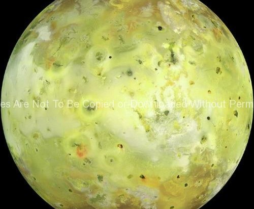
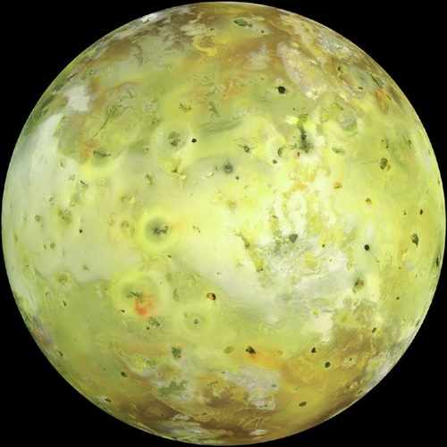
NASA Stock Photos – NASA’s Galileo spacecraft acquired its highest resolution images of Jupiter’s moon Io on July 3, 1999 during its closest pass to Io since orbit insertion in late 1995. This color mosaic uses the near-infrared, green and violet filters (slightly more than the visible range) of the spacecraft’s camera and approximates what the human eye would see. Most of Io’s surface has pastel colors, punctuated by black, brown, green, orange, and red units near the active volcanic centers. A false color version of the mosaic has been created to enhance the contrast of the color variations. The improved resolution reveals small-scale color units which had not been recognized previously and which suggest that the lavas and sulfurous deposits are composed of complex mixtures. Some of the bright (whitish), high-latitude (near the top and bottom) deposits have an ethereal quality like a transparent covering of frost. Bright red areas were seen previously only as diffuse deposits. However, they are now seen to exist as both diffuse deposits and sharp linear features like fissures. Some volcanic centers have bright and colorful flows, perhaps due to flows of sulfur rather than silicate lava. In this region bright, white material can also be seen to emanate from linear rifts and cliffs. Comparison of this image to previous Galileo images reveals many changes due to the ongoing volcanic activity. North is towards the top of the picture and the sun illuminates the surface from almost directly behind the spacecraft. This illumination geometry is good for imaging color variations, but poor for imaging topographic shading. However, some topographic shading can be seen here due to the combination of relatively high resolution (1.3 kilometers or 0.8 miles per picture element) and the rugged topography over parts of Io. The image is centered at 0.3 degrees north latitude and 137.5 degrees west longitude. The resolution is 1.3 kilometers (0.8 miles) per picture element. The images were taken on July 3, 1999 at a range of about 130,000 kilometers (81,000 miles) by the Solid State Imaging (SSI) system on NASA’s Galileo spacecraft during its twenty-first orbit. The Jet Propulsion Laboratory, Pasadena, California manages the Galileo mission for NASA’s Office of Space Science, Washington, DC.

keywords: Jupiter’s Moon, Galileo mission photos, NASA

Neptune and Triton Moon

Neptune and Triton Moon

Neptune and Triton Moon

NASA Stock Photos – This computer generated montage shows Neptune as it would appear from a spacecraft approaching Triton, Neptune’s largest moon at 2706 km (1683 mi) in diameter. The wind and sublimation eroded south polar cap of Triton is shown at the bottom of the Triton image, a cryovolcanic terrain at the upper right, and the enigmatic “cantaloupe terrain” at the upper left. Triton’s surface is mostly covered by nitrogen frost mixed with traces of condensed methane, carbon dioxide, and carbon monoxide. The tenuous atmosphere of Triton, though only about one hundredth of one percent of Earth’s atmospheric density at the surface, is thick enough to produce wind-deposited streaks of dark and bright materials of unknown composition in the south polar cap region. The southern polar cap was sublimating at the time of the Voyager 2 flyby, as indicated by the irregular and eroded appearance of the edge of the cap.

Keywords: NASA, Neptune, Space photos, Triton, Moon

Earth and Moon from Galileo Spacecraft GPN-2000-001437

Earth and Moon from Galileo Spacecraft

Earth and Moon from Galileo Spacecraft

NASA Stock Photos – During its flight, the Galileo spacecraft returned images of the Earth and Moon. Separate images of the Earth and Moon were combined to generate this view. The Galileo spacecraft took the images in 1992 on its way to explore the Jupiter system in 1995-97. The image shows a partial view of the Earth centered on the Pacific Ocean about latitude 20 degrees south. The west coast of South America can be observed as well as the Caribbean; swirling white cloud patterns indicate storms in the southeast Pacific. The distinct bright ray crater at the bottom of the Moon is the Tycho impact basin. The lunar dark areas are lava rock filled impact basins. This picture contains same scale and relative color/albedo images of the Earth and Moon. False colors via use of the 1-micron filter as red, 727-nm filter as green, and violet filter as blue. The Galileo project is managed for NASA’s Office of Space Science by the Jet Propulsion Laboratory.

Keywords: Earth, moon, Galileo spacecraft, NASA

Galileo Preparations 1989 GPN-2000-000672

Galileo Preparations 1989

Galileo Preparations 1989

NASA Stock Photos – In the Vertical Processing Facility (VPF), the spacecraft Galileo is prepared for mating with the Inertial Upper Stage booster. Galileo will be launched aboard the Orbiter Atlantis on Space Shuttle mission STS-34, October 12, 1989 and sent to the planet Jupiter, a journey which will take more than six years to complete
The Moon's North Pole GPN-2000-000473

The Moon’s North Pole

The Moon's North Pole

NASA Stock Photos – This view of the Moon’s north pole is a mosaic assembled from 18 images taken by Galileo’s imaging system through a green filter as the spacecraft flew by on December 7, 1992. The left part of the Moon is visible from Earth; this region includes the dark, lava-filled Mare Imbrium (upper left); Mare Serenitatis (middle left); Mare Tranquillitatis (lower left), and Mare Crisium, the dark circular feature toward the bottom of the mosaic. Also visible in this view are the dark lava plains of the Marginis and Smythii Basins at the lower right. The Humboldtianum Basin, a 650-kilometer (400-mile) impact structure partly filled with dark volcanic deposits, is seen at the center of the image. The Moon’s north pole is located just inside the shadow zone, about a third of the way from the top left of the illuminated region.

keywords: NASA, Galileo, Moon images

Global Color Mosaic of Triton

Global Color Mosaic of Triton

Global Color Mosaic of Triton

NASA Stock Photos – Global color mosaic of Triton, taken in 1989 by Voyager 2 during its flyby of the Neptune system. Color was synthesized by combining high- resolution images taken through orange, violet, and ultraviolet filters; these images were displayed as red, green, and blue images and combined to create this color version. With a radius of 1,350 (839 mi), about 22% smaller than Earth’s moon, Triton is by far the largest satellite of Neptune. It is one of only three objects in the Solar System known to have a nitrogen-dominated atmosphere (the others are Earth and Saturn’s giant moon, Titan). Triton has the coldest surface known anywhere in the Solar System (38 K, about -391 degrees Farenheit); it is so cold that most of Triton’s nitrogen is condensed as frost, making it the only satellite in the Solar System known to have a surface made mainly of nitrogen ice. The pinkish deposits constitute a vast south polar cap believed to contain methane ice, which would have reacted under sunlight to form pink or red compounds. The dark streaks overlying these pink ices are believed to be an icy and perhaps carbonaceous dust deposited from huge geyser-like plumes, some of which were found to be active during the Voyager 2 flyby. The bluish-green band visible in this image extends all the way around Triton near the equator; it may consist of relatively fresh nitrogen frost deposits. The greenish areas include what is called the cataloupe terrain, whose origin is unknown, and a set of “cryovolcanic” landscapes apparently produced by icy-cold liquids (now frozen) erupted from Triton’s interior.

keywords: Neptune system, Neptune, Triton

First Earth and Moon Picture

First Earth and Moon Picture

First Earth and Moon Picture

NASA Stock Photos – This picture of the Earth and Moon in a single frame, the first of its kind ever taken by a spacecraft, was recorded September 18, 1977, but NASAs Voyager 1 when it was 7.25 million miles (11.66 million kilometers) from Earth. The moon is at the top of the picture and beyond the Earth as viewed by Voyager. In the picture are eastern Asia, the western Pacific Ocean and part of the Arctic. Voyager 1 was directly above Mt. Everest (on the night side of the planet at 25 degrees north latitude) when the picture was taken. The photo was made from three images taken through color filters, then processed by the Image Processing Lab at Jet Propulsion Laboratory (JPL). Because the Earth is many times brighter than the Moon, the Moon was artificially brightened by a factor of three relative to the Earth by computer enhancement so that both bodies would show clearly in the prints. Voyager 1 was launched September 5, 1977 and Voyager 2 on August 20, 1977. JPL is responsible for the Voyager mission.

keywords: Moon and earth photo, spaces images, NASA, Voyager