Earth and Moon from Galileo Spacecraft GPN-2000-001437

Earth and Moon from Galileo Spacecraft

Earth and Moon from Galileo Spacecraft

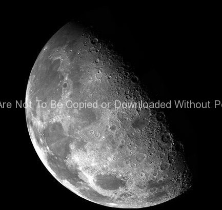
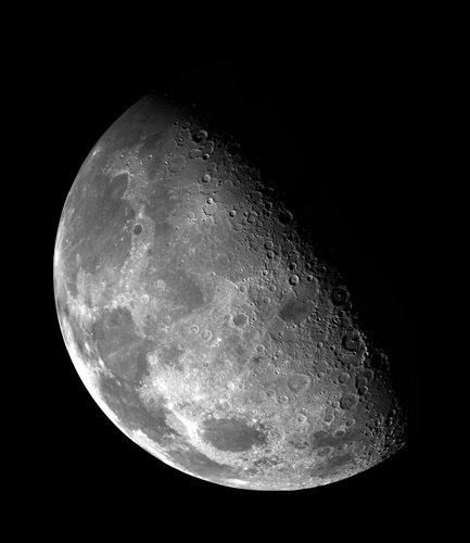
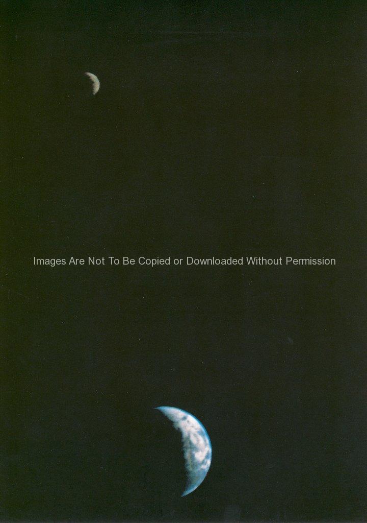
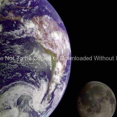
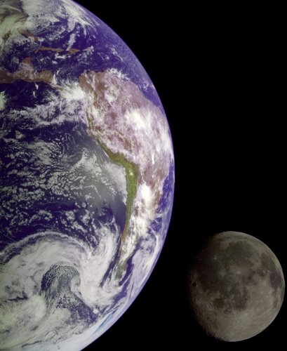
NASA Stock Photos – During its flight, the Galileo spacecraft returned images of the Earth and Moon. Separate images of the Earth and Moon were combined to generate this view. The Galileo spacecraft took the images in 1992 on its way to explore the Jupiter system in 1995-97. The image shows a partial view of the Earth centered on the Pacific Ocean about latitude 20 degrees south. The west coast of South America can be observed as well as the Caribbean; swirling white cloud patterns indicate storms in the southeast Pacific. The distinct bright ray crater at the bottom of the Moon is the Tycho impact basin. The lunar dark areas are lava rock filled impact basins. This picture contains same scale and relative color/albedo images of the Earth and Moon. False colors via use of the 1-micron filter as red, 727-nm filter as green, and violet filter as blue. The Galileo project is managed for NASA’s Office of Space Science by the Jet Propulsion Laboratory.

Keywords: Earth, moon, Galileo spacecraft, NASA

Galileo Preparations 1989 GPN-2000-000672

Galileo Preparations 1989

Galileo Preparations 1989

NASA Stock Photos – In the Vertical Processing Facility (VPF), the spacecraft Galileo is prepared for mating with the Inertial Upper Stage booster. Galileo will be launched aboard the Orbiter Atlantis on Space Shuttle mission STS-34, October 12, 1989 and sent to the planet Jupiter, a journey which will take more than six years to complete
The Moon's North Pole GPN-2000-000473

The Moon’s North Pole

The Moon's North Pole

NASA Stock Photos – This view of the Moon’s north pole is a mosaic assembled from 18 images taken by Galileo’s imaging system through a green filter as the spacecraft flew by on December 7, 1992. The left part of the Moon is visible from Earth; this region includes the dark, lava-filled Mare Imbrium (upper left); Mare Serenitatis (middle left); Mare Tranquillitatis (lower left), and Mare Crisium, the dark circular feature toward the bottom of the mosaic. Also visible in this view are the dark lava plains of the Marginis and Smythii Basins at the lower right. The Humboldtianum Basin, a 650-kilometer (400-mile) impact structure partly filled with dark volcanic deposits, is seen at the center of the image. The Moon’s north pole is located just inside the shadow zone, about a third of the way from the top left of the illuminated region.

keywords: NASA, Galileo, Moon images

Global Color Mosaic of Triton

Global Color Mosaic of Triton

Global Color Mosaic of Triton

NASA Stock Photos – Global color mosaic of Triton, taken in 1989 by Voyager 2 during its flyby of the Neptune system. Color was synthesized by combining high- resolution images taken through orange, violet, and ultraviolet filters; these images were displayed as red, green, and blue images and combined to create this color version. With a radius of 1,350 (839 mi), about 22% smaller than Earth’s moon, Triton is by far the largest satellite of Neptune. It is one of only three objects in the Solar System known to have a nitrogen-dominated atmosphere (the others are Earth and Saturn’s giant moon, Titan). Triton has the coldest surface known anywhere in the Solar System (38 K, about -391 degrees Farenheit); it is so cold that most of Triton’s nitrogen is condensed as frost, making it the only satellite in the Solar System known to have a surface made mainly of nitrogen ice. The pinkish deposits constitute a vast south polar cap believed to contain methane ice, which would have reacted under sunlight to form pink or red compounds. The dark streaks overlying these pink ices are believed to be an icy and perhaps carbonaceous dust deposited from huge geyser-like plumes, some of which were found to be active during the Voyager 2 flyby. The bluish-green band visible in this image extends all the way around Triton near the equator; it may consist of relatively fresh nitrogen frost deposits. The greenish areas include what is called the cataloupe terrain, whose origin is unknown, and a set of “cryovolcanic” landscapes apparently produced by icy-cold liquids (now frozen) erupted from Triton’s interior.

keywords: Neptune system, Neptune, Triton

First Earth and Moon Picture

First Earth and Moon Picture

First Earth and Moon Picture

NASA Stock Photos – This picture of the Earth and Moon in a single frame, the first of its kind ever taken by a spacecraft, was recorded September 18, 1977, but NASAs Voyager 1 when it was 7.25 million miles (11.66 million kilometers) from Earth. The moon is at the top of the picture and beyond the Earth as viewed by Voyager. In the picture are eastern Asia, the western Pacific Ocean and part of the Arctic. Voyager 1 was directly above Mt. Everest (on the night side of the planet at 25 degrees north latitude) when the picture was taken. The photo was made from three images taken through color filters, then processed by the Image Processing Lab at Jet Propulsion Laboratory (JPL). Because the Earth is many times brighter than the Moon, the Moon was artificially brightened by a factor of three relative to the Earth by computer enhancement so that both bodies would show clearly in the prints. Voyager 1 was launched September 5, 1977 and Voyager 2 on August 20, 1977. JPL is responsible for the Voyager mission.

keywords: Moon and earth photo, spaces images, NASA, Voyager